Hiking the Middle Fork of the Boise River, September 2017!
This particular venture was just one more futile attempt to locate the backpacking gear lost by Ezra the goat during last season's hiking. It was undertaken
in the face of a late summer snowfall in the Sawtooth mountains, but in my experience, these kinds of late-season snow events were basically 2" of snow,
that hangs around for 2 days. That little assumptive flight of fancy would be proven wrong in spades, at least in this case. This trailhead begins in Atlanta, ID,
at 5425',
and follows the Middle Fork of the Boise River for its entire length until it reaches its origination point at Spangle Lake at 8586', meaning
that
when you arrive at Spangle, you will have climbed over 3100' feet. Which, in the hiking world, is a fair bit of climbing, and in the Senior Citizen world,
where I currently reside, it is a bloody grunt!
Day 1 was supposed to be a RON at the Atlanta Trailhead (TH), with a hike-beginning on Wednesday. However, hiking partner showed up at my house
earlier
than expected, and therefore we showed up at the Atlanta TH much earlier than expected, therefore no choice but to begin the hike on Tuesday.
One of the characteristics of this particular trail, is that camping opportunities are few and far between. As a result, we arrived at the first real camping
location well into the last hours of daylight. This meant a scramble to get something to eat, rig the highline for the goats, find a place to hang the food,
and put up the evening's house (tent).
Wednesday morning was COLD! Could even be described as 'bitter'. At least that was what my hands and feet were telling me. Altitude here was
5900' feet, not
too much higher than the TH, so it must have been cold everywhere.
Began hiking late (10am or so) and so arrived at the designated lunch location (6400') a bit late, ran into some horse folks on their way back to Atlanta,
and so engaged in a delightful chat with them about the goats, etc. Finally got going again a bit late, which was biting solidly into our time
to the next
destination
at 7500',
which involved a lot of slog climbing. For about the last mile or more we were encountering 3-4" of snow on the trail. This, folks,
is an omen, and an omen of the first order, since the ultimate destination was 1100' feet higher than we were going to be for this night's RON.
Arrived at this camping locale with maybe 1-1/2 hour of daylight, so the scramble was on again. Sitting around eating dinner, the subject of tomorrow's hiking
was broached. The general consensus among the earstwhile hikers was Yikes! Let's get outta here! That was an easy conclusion to come to given
the snow and
wet we were surrounded by, and the healthy amount of altitude we had yet to conquer.
Morning was bitter squared, hands only about 20% functional, toes stinging from the cold, but after gathering our gear (gathering our wits took
a bit longer),
we began the trudge back down to reasonable altitudes.
One of the 'blessings' of this particular trail is that there are 5 stream crossings to navigate. 'Yeah, so what's so tough about that?' Well, the scenario for a stream
crossing proceeds thusly: Find a place to sit down (good places to sit are frequently scarcer than hen's teeth); take off shoes and socks; put on stream
crossing
shoes (COLD. Especially when wet from the previous stream crossing!); get gear (shoes mostly) situated on goats; place feet into water (which has the feeling of a
temperature near absolute zero); navigate across a stream in which the rocks are as slippery as if they were coated with ice; find another place to sit (same scarcity
on this side of the creek as the other); regain shoes from goats who have no vested interest in your feet issues, their only consideration is finding the best of
the streamside vegetation; put socks & shoes back on (remember feet are wet, always a joy to pull socks onto wet feet); try to stand up and get moving again
(remembering that you have now stiffened up from the inactivity). Every time you have to go through this charade you lose somewhere between 20-30 minutes
of hiking time.
Therefore, by the time we reappeared at the 1st evening's camping locale, we are back to the same old, same old; the 'get your stuff together'
scramble to get everything done before Oh-dark 30.
Finally, another bitter morning, 5.3 miles of trail, and a trip home in the magic carpet. The 'up side' of this last day was that this day was as close to ideal as is
possible for this time of year. It was truly spectacular. And on this trip out, you follow the Middle Fork much of the way out, the color of which is crystal
clear with just a shade of turquoise added for flavor. However, bottom line, 30 miles of hiking, and all we saw was the trail.
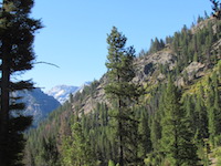
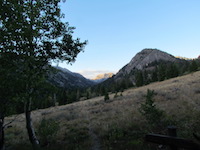 Day One Tuesday, 26 September |
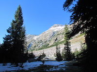 Day 3 28 September |
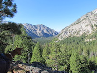 Day 4 29 September |
|---|